|
The Research Project IWRM-Vietnam is working on two different scales:
- Regional planning scale at the River Basin and Sub-basin level (ca: 1:300,000): DSS for IWRM Projects
- Local scale: Can Tho, Lam Dong and Nam Dinh Partial Projects.
Figure 1 shows the different scales and their relationship to the administrative levels in Vietnam.
The level for developing the DSS for IWRM is “River Basin” and “Sub-Basin” (parts of Cuu Long, Dong Nai, Song Hong). The objective of the DSS is to provide decision support on the overall planning level, but not at the local level, where, for example decisions about project investment are made.
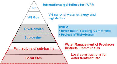
Figure 1: Administrative levels and corresponding levels of water resource management in Vietnam
The Research Project IWRM-Vietnam is divided into the work packages shown in Figure 2: 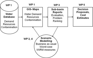
Figure 2: Work packages (WP) of the Project IWRM-Vietnam
In the following text, the intermediate results are presented:
To describe the current situation in water resources, land use and socio-economy, a database was established to create the following maps:
Water Use / Water Demand
D 1 Amount of water used / water demand
Water Resources (sustainable yield)
R 1 Sustainable groundwater yield
R 2 Sustainable surface water yield
R 3 Restricted and problem areas of water resources
Contamination Risk
P 1 Vulnerability of surface water resources
P 2 Vulnerability of groundwater resources
P 3 Wastewater discharge of point sources
P 4 Pollution potential of point and nonpoint sources
In a next step GIS maps were combined to obtain aggregated information. In this way GIS maps for information on water demand, water resources and contamination could be used:
- Water Use / Water Demand versus Water Resources (D1 + R1 + R2)
- Water Resources versus Contamination Risk (R1 + R2 + P3 + P4)
This makes it possible to identify problem areas (WP 3), to define proposals for interventions (WP4) and to develop cost estimates (WP 5). The results will be compiled as “sub-basin reports.”
The objectives of the methodology are to allow for better management of water resources, to facilitate interpretation and assessment of the data and to allow for combined management and assessment with other data relevant for water resources management.
The most important feature of the methodology is to process the data in a way which allows rapid understanding by professionals and decision makers of the general situation and the main problems. Another important factor is that the method has to be replicable in other localities throughout Vietnam. Both criteria require a considerable amount of generalization. On the other hand, transparency of the data processing is crucial to avoid misinterpretation of generalized conclusions. The presented maps show the methodology using the example of sub-basins of the Upper Dong Nai areas. |