|
Capital city: |
Nam Dinh City |
|
Population: |
1,975,181 (2006) |
|
Population density: |
1,197 capita/km² (2006) |
|
Area: |
1,649.86 km²(2006) |
|
Average temperature: |
24.4° C (2006) |
|
Average precipitation: |
1,285 mm (2006) |
|
Industry: |
Food production, textile industry,
mechanical industry, wood processing |
|
Agriculture: |
Paddy rice, cereals, maize,
soybeans, peanuts |
|
Land Use |
3 % Forest
59 % Agriculture
38% Other |
Geography
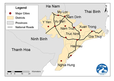
Nam Dinh is a coastal province in the southern
Red River Delta. It borders in the northwest on Ha Nam province, in the northeast on Thai Binh province, in the southwest on Ninh Binh
province and in the southeast on the East China Sea.
Nam Dinh province covers an area of 1,649.86 km². There are 10 administrative
units on the district level, three of them bordering on the sea. Nam Dinh City is the political,
cultural and economic center of Nam Dinh province. Nam Dinh City is located 90 km south of Hanoi and can be reached by Highways No. 1 and 21.
The topography of Nam Dinh province is
relatively flat. It lowers gradually from northwest to southeast. The province
can be divided into two regions: first the polder area of the low delta plain
(the lowest point is 3 m below sea level in Y Yen district), and then the
coastal plains outside the sea dyke. There are a few hills in the northwestern
part of the province (highest mountain “Goi” at 122 m elevation).
The coastline has a length of 72 km, but it is extensively
separated by large river mouths: Ba Lat River mouth (Red River), Day Rivermouth, Ninh Co River mouth and Lach Giang river mouth (So river).
Climate
The climate of Nam Dinh is characterized by a
hot wet rainy season, which is typical of the Red River Delta. The weather is influenced
by four seasons (spring, summer, autumn, winter). The summer is hot with high
rainfall and the winter is cold with low rainfall. The annual mean temperature ranges
from 23°C to 24°C. In winter the mean temperature ranges
from 16°C to 17°C; the coldest months are January
and February. The mean summer temperature is between 26°C and 28°C, with the hottest months being
July and August. The annual mean air humidity is about 80 – 85 %, the highest
air humidity of 90 % exists in March. Annual rainfall ranges from 1,700 – 1,800
mm and is distributed relatively evenly over the entire area of the province. The
main rains fall from May to October producing about 80% of the annual rainfall.
From November to April rainfall is very low, with some months having almost no
rain at all.
Nam Dinh province is situated on the Gulf of Tonkin. Therefore, every year it is
influenced by typhoons or tropical lows. Per year four to six typhoons occur on
average, mainly between July and October. In 2005 the strongest storm in 100
years hit Nam Dinh province. Large areas of the province were flooded after
many parts of the sea dyke were broken by the storm.
Economy
The province is influenced by the economic triangle Hanoi – Haiphong – Ha Long. It can therefore take advantage of a complex traffic network
including the transnational railway track, Highways 1, 10, and 21, a coastline
of 72 km, the river system of the Red River, Dao River, Day River and Ninh Co River,
various river ports, and the Thinh Long seaport that is under construction.
This is also a favorable condition for expanding trade and social exchange
within the province, the country and with other countries, and for taking a
leading role in realizing the strategy of economic and social development in
the “South Red River Delta” sub-region.
In Nam Dinh province there are more than 100
trade villages, many of them specialized in handicraft production like wood-carving
in La Xuyen and metal casting in Tong Xa (both in Y Yen district), silk
production and weaving in Phuong Dinh (Truc Ninh district) and floriculture in
Vi Khe (Nam Truc district).
Environment
The river network inside Nam Dinh province
consists of 530 km of rivers and streams, with a river density of 0.33 km/km². The
four large rivers alone (Red River, Day River, Dao River and Ninh Co River) add up to a length of 251 km. Between these main rivers a
system of 21 river channels is widely distributed in a fishbone shape, adding up
to 279 km. The water regime of the river system is clearly divided by wet and
dry seasons.
The river beds of the lower section of the
rivers are not very deep and the flow velocity is low. Therefore during the
rainy season many areas are flooded and waterlogged.
The coastal area of Nam Dinh province is
influenced by tides; the mean amplitude ranges from 1.6 m to 1.7 m, the highest
being 3.3 m, the lowest 0.1 m. The tides cause salt intrusion and increase the water
level in rivers near the coastal zone, and also the river and irrigation
channel system in the hinterland. The flow of the Red River and the Day River is influenced by the tide regime, leading to alluvial deposition by these rivers.
As a result, several large alluvial grounds like Con Lu and Con Ngan (Giao Thuy
district) or Con Troi and Con Mo (Nghia Hung district) have formed.
According to the soil the land surface of Nam
Dinh province can be divided into two regions. The northern region comprises Y
Yen, Vu Ban and My Loc districts and Nam Dinh City.
The southern region consists of Truc
Ninh, Nam Truc, Xuan Truong, Hai Hau, Nghia Hung and Giao Thuy districts. Most widespread
soils are young alluvial soils (fluvisols) that cover 82 % of the land surface.
Alkaline soils cover 14 % of the province and other soils covering small parts
of the land are sandy soils, aluminous soils and feralitic soils. Generally the
main soils of Nam Dinh province are alluvial soils developed from river
deposits. The quality is suitable for the development of many kinds of plants.
Literature:
Bo Tai
Nguyen Va Moi Truong (Ministry of Natural Resources and Environment), Trung Tam
Dieu Tra Quy Hoach Dat Dai (Centre for Land Use Research and Planning), Bao cao ket qua du an. Xay dung mo hinh chuyen
doi co cau su dung dat phuc vu cong nghiep hoa, hien dai hoa nong nghiep, nong
thon tinh Nam Dinh, Ha Noi, 2007, (Final project report. Planning the conversion of the land
use structure under influence of industrialization and modernization of
agriculture in rural areas of Nam Dinh province, Hanoi, 2007)